Jul 20
20
COVID19 Risk Levels in KPBSD
COVID19 Risk Level in the Kenai Peninsula Borough School District
UPDATE:
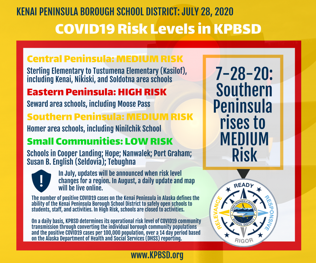
On July 28, 2020, Southern Peninsula rose from LOW to MEDIUM Risk
On July 27, 2020, Central Peninsula dropped from HIGH to MEDIUM Risk
Current Risk Levels effective July 19, 2020, July 27, 2020, July 28, 2020, until further notice*
Central Peninsula: HIGH (on 7-27-20 risk dropped to MEDIUM)
Eastern Peninsula: HIGH
Southern Peninsula: LOW (on 7-28-20 risk rose to MEDIUM)
When the onset of COVID-19 happened, the need to make rational and informed operational decisions became primary for the health and safety of our students, staff, and communities. KPBSD incorporated science-based guidance to assist in our decision-making processes.
Beginning on or before August 1, KPBSD will provide daily COVID19 risk updates for our schools on a new dedicated webpage at www.KPBSD.org, and include a robust visual risk level map of Kenai Peninsula schools on the district and school website homepages for easy reference. Included will be what to expect with each risk level.
*RISK LEVELS Documents. (To read the most recent reports, go to www.KPBSD.org)
The KPBSD is divided into geographical risk areas:
- Central
Kenai Peninsula includes Sterling to Kasilof,
extending through Kenai, Nikiski, Soldotna, and DHSS “other north” communities:
Aurora Borealis Charter School; Connections Homeschool; Kaleidoscope Charter School; K-Beach Elementary School; Kenai Alternative School; Kenai Central High School; Kenai Middle School; Mountain View Elementary School; Nikiski Middle-High School; Nikiski North Star Elementary School; Redoubt Elementary School; River City Academy; Skyview Middle School; Soldotna Elementary School; Soldotna High School; Soldotna Montessori Charter School; Sterling Elementary School and Other North: Tustumena Elementary School
- Eastern
Kenai Peninsula includes Seward area, including
Moose Pass
Moose Pass Elementary School; Seward Elementary School; Seward High School; Seward Middle School
- Southern
Kenai Peninsula includes Homer area, north to
Ninilchik, Anchor Point, Fritz Creek, and DHSS “other south” communities:
Chapman School; Connections Homeschool; Fireweed Academy; Homer Flex School; Homer High School; Homer Middle School; McNeil Canyon Elementary School; Paul Banks Elementary School; West Homer Elementary School; and Other South: Kachemak-Selo School;Nikolaevsk School; Ninilchik School; Razdolna School; Voznesenka School
- Schools in Individual or Remote Communities
Cooper Landing School; Hope School; Nanwalek School; Port Graham School; Susan B. English School (Seldovia); Tebughna School
The Alaska Department of Health and Social Services (DHSS) created a tool with three levels of alert based on the amount of community transmission on a per capita incidence of cases per 100,000 population as part of their plan to reopen long-term care facilities to visitors. Every day the DHSS calculates the number of new cases of COVID-19 per 100,000 residents, then averages it over the past 14 days. The DHSS article and chart are found at this link: http://dhss.alaska.gov/dph/Epi/id/Pages/COVID-19/alertlevels.aspx
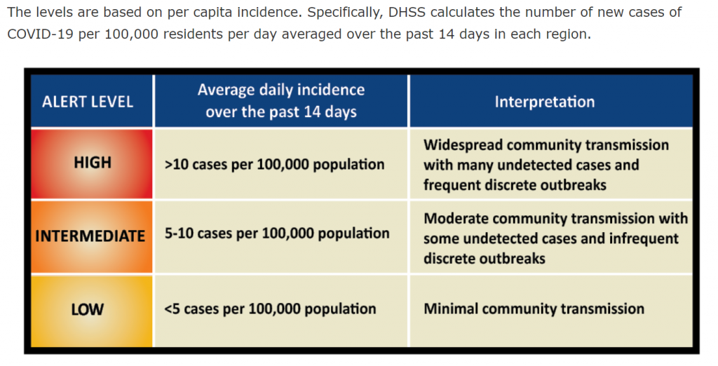
The DHSS article specifically states:
“These community transmission levels were developed to inform decisions about allowing visitors to long-term care facilities. However average daily per capita incidence may inform decision making in other sectors as well, such as schools, institutions of higher education, and businesses.”
The Alaska School Activities Association (ASAA) adopted this modeling to determine risk levels for student activities and sports.
KPBSD believes that the safety of our staff and students should be as important as the safety of our senior citizens, so we have adopted the same numbers used by DHSS. We have created a “KPBSD Level of Determination by Community-Region” chart that converts the population of the borough and its communities on the “cases per 100,000 population” standard that the State used. The KPBSD chart shows case counts in two ways, the daily average case rate over fourteen days, and the total maximum number of cases in the last 14-day period.
KPBSD created a “Resident Coronavirus Cases On The Kenai Peninsula” chart to track the daily number of cases on the Kenai Peninsula as reported by the State of Alaska on the upper portion of the chart. On the bottom half of the page, cases are grouped by Region. The cases are shown in three different ways:
- a total of all cases
- a total of cases in the last 14-day period
- a daily average in the last 14-day period
The latter two numbers are used in coordination with the “KPBSD Level of Determination by Community-Region” chart to determine what alert level each Region is in for KPBSD operations.
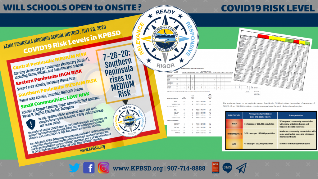
Reports for Resident Coronavirus Cases On The Kenai Peninsula and KPBSD Level of Determination by Community-Region were moved near the top of this page.
Links
In July, posts will only be made when risk levels change. Beginning August 1, daily count updates will be live online and posted to KPBSD social media. Kindly note: if you ask questions in a comment, I’ll do my best to review them several times a week, and respond. However, I will be out of the office July 20-25, 2020, so there will not be any responses. I appreciate your patience and understanding until the new risk level webpage and map under development for the school year is live on August 1. – Pegge Erkeneff, Director of Communications